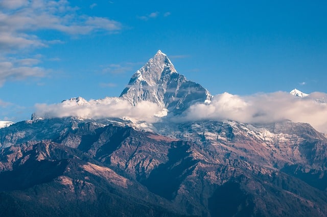
Himalayan Mountain: Range, Location and Interesting Facts
The Himalayan mountain is a collection of mountains in Asia, sometimes referred to as the ‘Himalayas’ or ‘the abode of Snow’ in Sanskrit. These mountains form a huge range of mountains which surround the western and southern edges of the Tibetan plateau. Himalayan Mountains separate the plains of the Indian subcontinent from those of the Tibetan plateau.
Notable peaks in the Himalayan system include the well known Mount Everest (standing at 8,850m / 29,035 ft), which is on the Nepal-Tibet border; the second highest peak, known as K2 or Mount Godwin Austen (standing at 8,611m / 28,251 ft), located on the border between China and Jammu and Kashmīr, a territory claimed by India and Pakistan; the third highest peak, Kanchenjunga (standing at 8,598m / 28,209 ft) on the Nepal-India border; Makalu (8,481 m / 27,824 ft) on the Nepal-Tibet border; Dhaulagiri (standing at 8,172 m / 26,811 ft) and Annapurna 1(standing at 8,091m / 26,545 ft) in Nepal; Nanga Parbat (standing at 8,125m/26,657 ft) in the Pakistani-controlled portion of Jammu and Kashmir; and Nanda Devi (standing 7817m / 25,645 ft) in India.
Himalayan Mountain Range
The Himalayan Mountain forms a broad continuous arc for nearly 2,600 km (1,600 mi) along the northern fringes of the Indian subcontinent starting from the bend of the Indus River at the northwestern region to the Brahmaputra River in the east. The Himalayan Mountain range averaging 320 to 400 km (200 to 250 miles) in width, rises sharply from the Gangetic Plain. To the North of this mountain belt lies the Tibetan Plateau (Qing Zang Gaoyuan). The Himalayan Mountain range is the largest in the world and it exists wholly in Asia.
Himalayan Mountain Location
The Himalayan Mountain stretches from Mainland China in the East to Pakistan in the West across Nepal, Bhutan, Tibet and Northeast India. The western anchor of the Himalayas lies in Pakistan to the South of the Indus River, while its Eastern anchor is Mount Namcha Barwa to the west of the great Bend of the Yarlung Zangbo River. Specific locations of the Himalayas in Asia are as follows:
Location of The Himalayas in Tibet
Starting from Ngari Prefecture at the west to Nyingchi prefecture in the south-eastern region, the Himalayas fringe Tibet in a huge arc along the region’s western, south-western, and southern borders with India, Nepal, and Bhutan. About 14 mountains in the world exceed 8000 meters, six of which are near Tibet, with one 8,000-plus meter mountain, Shishapangma, lying wholly within the region.
Along the Tibetan border shared with Nepal, lies Mount Everest, Mount Lhotse, Mount Makalu, Mount Cho Oyu, and Gyachung Kang. Known as the Himalaya to the western world, in Tibetan the name translates as “The Land of Snow”.
Location of Himalayas in Nepal
It runs along the entire northern edge of the country, the Himalayas form the natural boundary between Nepal and China and form the border between the two countries. Nepal is home to about 31 of the many mountains in the Himalayan Range, with eight of the fourteen 8,000-plus meter tall mountains being in Nepal.
Mount Lhotse, Mount Everest, Mount Makalu, and Mount Cho Oyu are shared with Tibet and lie directly on the Sino-Nepal border while Kanchenjunga is shared with India along the border with Sikkim in the east of Nepal.
Nepal has three of the 8,000 plus meter Mountains that lies wholly within its border, which are Dhaulagiri I, Manaslu, and Annapurna I.
Location of Himalayas in Bhutan
Located in the midst of the Eastern Himalayas on Tibet’s southern border, the Kingdom of Bhutan is a small Himalayan country that is the last real Shangri-La of the Himalayas. its Himalayan border along Tibet is just 470 kilometers in length. Only four (4) of the world’s 110 highest mountains (all over 7,000 meters) are on the border with China in Tibet.
Gangkar Puensum is the highest peak in Bhutan at 7,750 meters, followed by Kula Kangri (7,538m), Jhomolhari (7,326m), Tongshanjiabu (7,207m), and Kangphu Kang (7,204m).
Location of the Himalayas in India
India has a relatively small area of Himalayan Mountains when compared with other countries in Asia. Arunachal Pradesh in the east and Sikkim have short areas of mountains on their northern borders with China, while Himachal Pradesh and Uttarakhand in the north have the longest section of mountains.
Indian does not have any of the world’s fourteen (14) highest mountains in the world; however, it has 22 mountains in the Himalayas that are over 7,000 meters. Nanda Devi is India’s highest mountain in the Himalayas. It lies in Uttarakhand at an elevation of 7,816 meters.
Interesting Facts About Himalayan Mountain
Below are some interesting facts about The Himalayas:
Fact 1: The Himalayan Mountain system includes over fifty (50) mountains exceeding 7,200m (approximately 23,600ft).
Fact 2: Mount Everest is referred to as ‘Sagarmatha’ by Nepalese people. This literally means ‘Goddess of the Universe’. Tibetans refer to Mount Everest as ‘Chomolungma’. Mount Everest is named after a British Army officer, Colonel Sir George Everest who was India’s surveyor General for 13 years from 1830 to 1843.
Fact 3: Due to its length, the Himalayan mountain system stretches across six countries in total. The countries are: Bhutan, Afghanistan, India, Pakistan, Tibet and Nepal.
Fact 4: Total area of land covered by the Himalayas is about 612,021 square km., which represents 0.4% of the total land area on Earth.
Fact 5: Many large perennial rivers in the world have The Himalayas as their source. Such rivers can classified as: The Ganges-Brahmaputra river system and the Indus river system.
Fact 6: The rivers on the western side of the Himalayas make up The Indus river system. Indus is the largest of all the rivers on that other side. The Indus river, along with other western rivers like Sutlej, Beas, Chenab, Jhelum and Ravi etc come together to form the Indus Basin. Indus comes from Tibet, flows southwest to enter India and then moves to Pakistan to finally drain into the Arabian Sea.
Fact 7: The other river system, known as the Ganges Brahmaputra system consists of three main rivers – the Yamuna, Brahmaputra and The Ganges. Brahmaputra’s origin is also in Tibet. River Brahmaputra and others meet in Bangladesh to finally drain through the largest known river delta in world – the Sunderbans into the Bay of Bengal.
Fact 8: Himalayas is the home of several high peaks. It holds a record of the maximum number of highest peaks among any mountain range in the world. Out of 14 heights peaks in this world, The Himalayas hold 9.
Fact 9: The Himalayan Mount Everest is the highest peak in the world above sea level. It stands at 8,850 meters or 29,035 feet.
Fact 10: Nanga Parbat, Makalu, Masherbrum (K1), Kamet, Rakaposhi, Gurla Mandhata, Kailash Kongur Tagh etc. are some of the famous peaks of the Himalayan Mountain system. Nanga Parbat and Makalu both exceed 8,000 meters in height.
Fact 11: The Himalayan Mountain region are geologically active, thus, the region is prone to natural phenomena such as tremors, landslides and earthquakes.
Fact 12: Mount Everest sit in the Great Himalayan Mountain zone of the Himalayan. The Great Himalayan Mountains remain perpetually covered with snow, which indicates that snow never melts there.
Sources:
- Retrieved from: https://en.m.wikipedia.org/wiki/Himalayas
- 40 interesting Himalayas facts. By Sankalan Baidya (2015, December, 12). Retrieved from: https://factslegend.org/40-interesting-himalayas-facts/